Social Icons

Featured Posts

.

Saturday, May 30, 2015

Kayaking Lake Boon

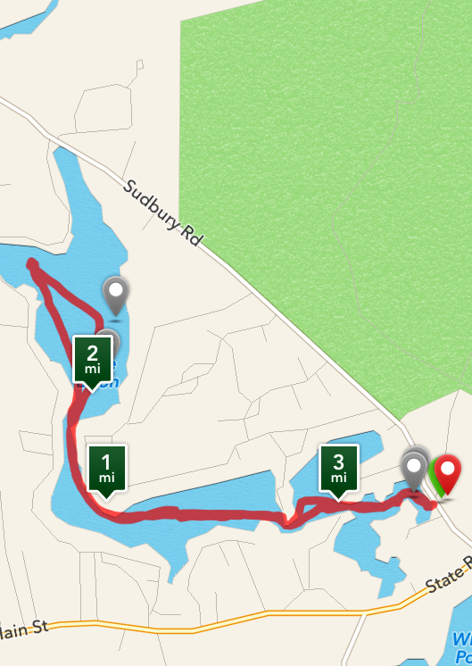
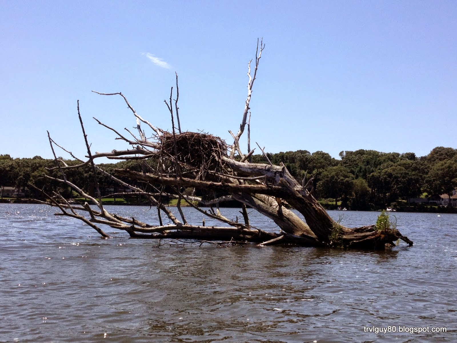
With the sun shining and having a rare day off I decided it would be a perfect day to go kayaking. Dan and I arranged a time with my brother and his family to check out Lake Boon. Lake Boon is a 163 acre lake located on the Hudson/Stow line.

Located a short distance from his house we loaded up the kayaks and their canoe. The lake is long and relatively narrow made up of four basins. 2 larger areas called Boon Pond and the Ramshorn Meadows as well as two swamp areas.  The meadows and swamp areas formed when a dam was built on Barton Road in Stow. The dam is a by-product of our industrial age.

We began our exploration from Dawes Lot located along Sudbury Road in the smaller of the two swampy areas.  From there we paddled along the shores of Ramshorn Meadows before passing through the Narrows into Boon Pond.

Many of the homes surrounding the lake are merely summer cottages while others have morphed into much more luxurious year round homes.  Historically Lake Boon was a hit amongst city dwellers who had once taken the train out to the area during the summer months and staying in lake side hotels. With the introduction of the car the Lake lost favor and today is surrounded only by homes.

With the sun beating down on us we all decided we would take a dip in the cool refreshing waters. I taught Dan and Grace how to exit their kayaks with out flooding it with water or capsizing. They each did a nice job. Chris pushed Aidan and Elyse off the canoe and into the lake with a splash. Those two are like fish they love the water so much.

We enjoyed the cool water and a chance to swim but after a short while we decided to get back underway. I quickly showed Dan and Grace how to reenter a kayak from the water without capsizing the boat while my brother taught Aidan how to reenter the canoe.

Once we were all back aboard we continued along heading for the dam. Having reached the other side of the lake we headed back. I could feel the sun since the dip in the lake had washed off my sunscreen but continued on.

The return trip seemed to go quicker and it wasn't long before we were back at the ramp. It was then we discovered Grace had taken her car key swimming and it was no lost to the depths of Boon Lake. We managed to get all three kayaks on the roof of my car and brought them back to my bothers while we decided what the best course of action would be. It all worked out after picking up her spare key and on the whole the day went great. Its a nice little lake to float around on and enjoy on a hot summer day.

Saturday, July 12, 2014

Kayaking to the Old Saybrook Breakwater "Outer" Lighthouse

I woke up to the sun shining and Long Island sound smooth as glass and decided it was a perfect day to kayak to the Old Saybrook Breakwater Light. I didn't load up the new roof rack for nothing and it was time to get the Kayaks in the water. The Breakwater light is known locally as the Outer Light and is one of two lighthouses marking the opening to the Connecticut River.

The Breakwater/Outer Light is the youngest of the two and was constructed 75 years after its older brother known as Lynde Point Light on a rocky jetty. I knew the history of the lighthouse well having watched its green flash in the distance every 6 seconds and when foggy a blast of the horn every 30 seconds. Many a night I watched its green light pulse from my bedroom window. It was lit for the first time in 1886 and stands at only 49 feet. While I have never been in it I am told it has 4 floors with a tiny staircase inside.

It had even made the local news when it was reported that it was to be sold by the federal government and the local town had been rumored to be interested in buying it. I don't think it actually happened however and I had heard that it was bought by a private family.

The lighthouse is a prominent feature along the shoreline and even graces the state license plate. It has survived numerous hurricanes and stands as a beacon to any who venture up or down the Connecticut river.


After a healthy breakfast I pulled the kayak's out and carried them down our new fortified sea wall to the beach which its self had survived many a hurricane until Hurricane Sandy did some damage a years ago.

Once in the water I began the roughly 2 mile trip along the Old Saybrook shoreline passing the Knollwood & Fenwood Pier's before paddling straight out to the Outer Light. The sea stayed calm and in no time I was bobbing around as I relaxed and took in the Light House.

A few guys had set up shop using the breakwater as a fishing spot. It was a little choppy since many boats were going up and down the river. The current was also keeping us moving. Having forgotten a hat and not put any sun lotion on we decided to head back. This time we must have been fighting the tide since the current made it more difficult to return. We opted to paddle along the breakwater and along the shoreline passing Katherine Hepburn's old summer cottage along the way. I have heard that the house is back on the market minus a portion of land for $15 million.

It took about 55 minutes to paddle back compared to the 35 minutes it took to get there and it was obvious we were both a bit tired and maybe a little burnt. Round trip it was 4.11 miles and took my just over an hour and 30 minutes to make the trip. I got some great pictures and enjoyed the paddle.

Tuesday, July 8, 2014

Back on the Water

About a 18 months ago my roof rack was unceremoniously stripped from my vehicle by thieves. It was locked but they managed to circumvent the locking mechanism. They didn't get everything but enough to prevent me from being able to transport either boat or bike. What they didn't take they damaged and the rack was pretty much a total loss. Thankfully I never leave the accessories on the rack so I still had those.

I could have bought a new rack but my car was older and I couldn't justify buying a new rack for a vehicle that was nearing the end. It put a big cramp kayaking any place new and as a result I was confined to the lake where I stored my kayak.Having grown up on that lake there isn't much left to explore or discover and so I focused more on other activities.

Recently I purchased a new vehicle. this time I got a SUV and it had the roof rails. Ready to get back on the kick of exploring I purchased a new rack. This coming weekend I will be loading up the gear for its first trip in a long while and hopefully the first of many trips to new places to explore.

Friday, September 7, 2012

Task 94 - Kayak 6 new places (2/6) - Nashoba Paddler (Groton, MA)

Location:   Nashoba PaddlerRating:       3-Stars

With the dog days of summer behind us and fall fast approaching we took advantage of the beautiful weather and decided to explore the Nashua and the Squannacook Rivers. Our journey began at Nashoba Paddler where we had scheduled appointment with the owner. (Note that after Labor Day you must schedule an appointment)

After paying for three hours in two old town kayaks we launched into the calm waters of the Nashua River and began our journey south towards the confluence of the Nashua and Squannacook rivers. Like most New England water ways the low the water levels were very noticeable. In addition to the low water levels the river was littered with downed trees many of which jutted out into the river.

If you are looking for excitement then this isn’t the river for you. If you are looking for a relaxing peaceful paddle down a lazy river then check it out. There wasn’t much to see along the river since it is flanked by conservation land and the Groton Town Forest with the exception of the Groton School Boathouse and a few bridges.

Along the river we saw a few fish and even fewer birds. We did get a treat and saw a huge snapper turtle with a shell that probably measured a good 14 inches. Sadly I couldn’t get a good picture of him since he quickly hid in the plant life at the bottom of the river.

Next, we stopped at the abandoned rail bridge and climbed up to get a different perspective of the river. The bridge was still structurally sound but showing its many years of neglect. It is a testament to the old days of transportation.

Just around the bend from the rail bridge was the confluence of the two rivers. The owner of Nashoba Paddler told us that if we explored the Squannacook River we would see nests (piles of river rock) built by the freshwater eels. It was interesting to see these nests and even more of a mystery of how they built them. While we didn’t see any eels we certainly did see lots of their handy work. Unfortunately the Squannacook river was barely passable from the start and with the fallen trees we didn’t manage to make it very far.

We continued a little farther down the river until we reached the Route 2A overpass. Having travelled a little more than 3 miles and 1.5 hours down the river we decided our hunger was getting the better of us and we would head back.

Our return trip was somewhat quicker since we made no stops or detours and we were travelling with the current. Overall it was a good day but I am not sure I would return. I thought that the price of 88$ for two people for 3 hours was steep for a river that lacked anything really interesting and equipment that was average at best. My kayak seat was damaged and could not be adjusted. Unfortunately I didn’t discover that until we were a mile down the river. We also returned to find no one at the shop and we were left padlocks to secure the kayaks. While we expected that since she had said she may not be there we didn’t like the responsibility of having to secure the kayaks and leaving the other equipment unsecured.


Sunday, July 22, 2012

Task 94 - Kayak 6 new places (1/6) - Kayaking the CT River (Essex,CT)

Location: Connecticut River (South Cove, Essex,CT)

Dan and I decided after breakfast that we would like to Kayak along the Connecticut River in Essex. The scenery is amazing with the marina's and all the power and sail boats. The Connecticut River makes a sharp turn in Essex and as a result the river created South Cove which provides a great place for boaters like me to stop to Kayak and enjoy the natural beauty of the shoreline it has carved.

We started our kayaking trip at the end of Main Street at the Essex Town Dock. They have a great launch ramp here that is great for canoe's and kayak's as well as for  jet Ski's and power boat's. Once we were in the water we paddled along the shoreline past a few of the marina's which had a few seriously large yacht's docked. The Lucky Seven was at the end and it was really a beauty.

We then entered South Cove with Thatchbed Island on our left and the main land on our right. South Cove is a quiet well protected cove. The houses along this stretch of the river vary greatly from the classic New England styles to the far more contemporary homes. It also was home to a variety of wildlife. We saw snowy egrets, swan's and comorants nesting and swiming around the uninhabited Thatchbed Island.

As we rounded the cove and along the front of Thatchbed Island we encountered a small boat with a fisherman hoping to catch some local seafood. He hadn't caught anything yet and I doubt he did.

As we approached the marina's again we went a little farther out and relaxing amungst the many sailboat's morred in the river before returning to the launch ramp.

Parking was pretty easy considering it was a beautiful weekend. I think it is mainly because there isnt too much to be found in the way of shops at this end of Main Street. Next time I am going to go the other way and explore North Cove and the Fall's River that flows into it.


Wednesday, June 20, 2012

Webster Lake

Kayaking: Webster Lake
Distance:  3.56 Miles
Time: 1 hour 20 minutes


Today in place of the gym again Jason and I went a little farther then we did last week. We decided to travel around the entire parameter of Middle Pond.

Again we started at Killdeer Island and went west along the shoreline before crossing from Indian Point to Union Point. We continued along the shoreline to Point Pleasant and into Mumford Cove. Again we went around Well Island, Long Island and continued along the shoreline past Point Breeze and the Lower Narrows. We continued along passing Bates Point and explored Winter Cove before heading back torwards Killdeer Island. This trip took us really no more time but we covered alot more water and traveled 3.56 miles.

Next time I think I will explore North Pond. I'll post some of the pictures later.